


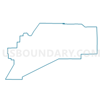
Anderson Precinct, Denali Borough, Alaska
About
Outline

Summary
| Unique Area Identifier | 523304 |
| Name | Anderson Precinct |
| County | Denali Borough |
| State | Alaska |
| Area (square miles) | 3.47 |
| Land Area (square miles) | 2.96 |
| Water Area (square miles) | 0.51 |
| % of Land Area | 85.17 |
| % of Water Area | 14.83 |
| Latitude of the Internal Point | 64.35204060 |
| Longtitude of the Internal Point | -149.17791180 |
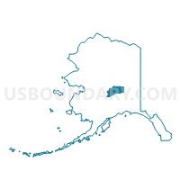
Maps

Graphs
Select a template below for downloading or customizing gragh for Anderson Precinct, Denali Borough, Alaska


Neighbors
Neighoring Voting District (by Name) Neighboring Voting District on the Map
- Clear Precinct (Part; Also See Part In Yukon-Koyukuk Census Area), Denali Borough, AK
- Nenana Precinct, Yukon-Koyukuk Census Area, AK
Top 10 Neighboring County Subdivision (by Population) Neighboring County Subdivision on the Map
- Koyukuk-Middle Yukon census subarea, Yukon-Koyukuk Census Area, AK (3,219)
- Denali census subarea, Denali Borough, AK (1,826)
Top 10 Neighboring Place (by Population) Neighboring Place on the Map
Top 10 Neighboring Unified School District (by Population) Neighboring Unified School District on the Map
Top 10 Neighboring State Legislative District Lower Chamber (by Population) Neighboring State Legislative District Lower Chamber on the Map
- State House District 8, Denali-University, AK (19,960)
- State House District 6, Interior Villages, AK (14,235)